FNQ Sustainable Cropping INC
About FNQSC
Northern Queensland’s unique environmental conditions necessitate specific farming practices, different from southern regions. The existing research focus on the south leaves a knowledge void for northern producers, creating a critical need for collaborative, region-specific research to enhance crop production in Northern Queensland. To address these challenges FNQ Sustainable Cropping (FNQSC) was formed in 2022 and has memberships of mixed cotton, grain, cattle producers, and agribusinesses. The principle aims of the grower group are to establish a peer-to-peer learning network to enable producer led sustainable broadacre cropping innovations and focal point for cotton supply chain development in North Queensland. The group was also endeavours to provide a conduit for engagement in participatory action research and cropping diversification in Far North Queensland.
Regional Boundaries
Within this region we have defined five distinct sub-regions built around the regional shire boundaries (see Figure 2). These sub-regions are:
• Dry Tropics – includes Burdekin, Townsville, and Charters Towers
• Wet Tropics – includes Hinchinbrook, Cassowary Coast, and Cairns
• Atherton Tablelands – includes part of Tablelands
• Cape York – includes Cook, Aurukun, Torres and part of Carpentaria
• Gulf – includes Burke, Mornington, part of Carpentaria, Croydon, Etheridge and part of Tablelands.
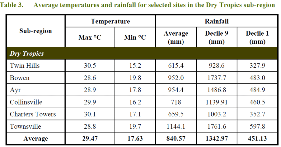
(source: Queensland Primary Industries & Fisheries’ north region An analysis from the top May 2009)

Dry Tropics
Coastal areas
The extensive deltas, levees and flood plains which dominate the landscape in the coastal sections of this sub-region are typically gently sloping alluvial plains which lead to mangrove and salt flats along the lower coastal areas. Groundwater was a major driver for early agricultural development in the area. Currently, two water boards
manage the recharge to the groundwater system in the Burdekin Delta to maintain groundwater levels and prevent seawater encroachment. About 43150 hectares of deep, fertile, sandy, clay loam soils support the irrigated production of sugar cane. Producers are now beginning to establish rotations and diversify into alternate crops. The area has specialised vegetable and mango farmers.
The Burdekin River Irrigation Area, consisting of approximately 35000 hectares, was established in 1988 with the construction of the Burdekin Falls Dam. The scheme is developed on heavy clay flood plain soils that have been used for rice production, but are now predominantly used for sugar cane.
Approximately 8 million tonne of sugar cane is crushed annually by four mills owned by CSR in the Lower Burdekin area. The area produces about 25% of the Queensland sugar cane crop.
Other areas of the coastal plain grow horticultural crops – both vegetable and tree crops – based on access to groundwater supplies. The coastal plains are also a major mango production area.
Interest in major prawn and finfish aquaculture developments is continuing to grow in this sub-region. Three extensive aquaculture enterprises, at various stages of development, will cover an area of approximately
Rangelands
To the west the topography changes with the occurrence of the Uplands region. This elevated and undulating landscape forms grazing lands on generally less fertile gradational earths and shallow duplex
soils. These soils are susceptible to erosion where there is limited ground cover. The area is within both the Brigalow Belt North and Einasleigh Uplands vegetation communities and is characterised as woodland and savannah rangelands. Over 70% of the area still retains remnant woody vegetation. Urban settlement is scant, with Charters Towers the major centre and small rural villages of less than 200 people. The rangelands predominantly support an extensive cattle industry, although isolated pockets of irrigated farming occur. The area is a major producer of store cattle for the live cattle export market and the southern fattening trade. Improvements in beef production have relied on the infusion of Bos indicus cattle, the introduction of the legume Stylosanthes spp and supplementary feeding for both improved fertility and production. Woody weeds that have proliferated since early gold mining are a threat to the productive use of the land. The area is under close scrutiny in relation to sediment losses causing water quality deterioration to the Great Barrier Reef Lagoon.
Opportune cropping of cotton and other cash crops occurs in the Belyando-Suttor catchments when river flows enable flood harvesting of water into large on-farm storage areas.
Historically, gold, tin and more recently nickel mining are important extractive industries in the region and account for the major minerals produced in the sub-region.
(source: Queensland Primary Industries & Fisheries’ north region An analysis from the top May 2009)
Wet Tropics
The climate of the Wet Tropics is unique in Australia. Rainfall is the distinguishing feature of the Wet Tropics. The annual rainfall is variable and seasonal and is dominated by major depressions, monsoon troughs and
cyclones. Cyclones are common between December and April, with a frequency of four to six per year of which, on average, two cross the coast. This sub-region is dominated by rugged mountain ranges, which include the highest mountains in Queensland.
The mountains and some of the associated lower hills and undulating plains which receive a high and consistent rainfall (>2000mm), historically support an extremely diverse array of the lush, complex, tropical mesophyll rainforest and vine forests. Approximately 900000 hectares are now protected by the Wet Tropics World Heritage Area and are an important tourist destination and nature conservation area.
Mangrove, samphire, beach vine forests and other communities occur on the saline estuarine plains and adjacent coastal landscapes. The major occurrence of wetlands is on the littoral shores, the alluvial and colluvial back plains, floodplains, stream deltas and permanent fast flowing streams. Within this sub-region eighteen sites covering more than 1.8 million hectares are considered to be of environmental importance to Queensland and three sites covering 61470 hectares are of national importance.
The deep red kandosol soils support both rainforest and eucalyptus forests. These areas were harvested historically for timber from about the 1880s. After clearing, the soils are favourable for cropping but are subject to water erosion problems on slopes. Substantial areas currently support sugar cane, which is now grown using a green cane trash blanket approach to minimise soil erosion.

Atherton Tablelands
The Atherton Tablelands sub-region is an elevated plateau consisting of the Atherton and Evelyn Tablelands and the Mareeba region. It has an average altitude of 750m above sea level, ranging from around 1100m on the ranges in the east to 450m at Mareeba.
Climate (both rainfall and temperature) varies across the Atherton Tablelands as a result of the change in altitude. Areas on the Atherton Tablelands can experience occasional frosts during winter.
(source: Queensland Primary Industries & Fisheries’ north region An analysis from the top May 2009)
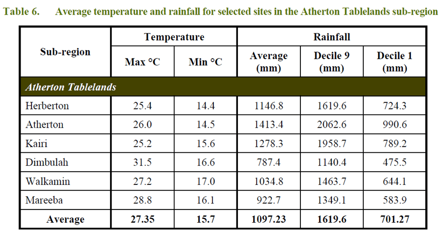
(source: Queensland Primary Industries & Fisheries’ north region An analysis from the top May 2009)
The Atherton Tablelands sub-region encompasses the western fringe of the Wet Tropics bioregion and the northern aspects of the Einasleigh bioregion. The extensive plateau area, with basalt derived fertile soils, supports both eucalypt and rainforest vegetation. Before clearing, a mosaic of closed forest communities dominated the region on the basaltic soils of higher rainfall and open eucalypt forests, and woodlands occurred in the drier sections. Areas of the rainforest are now protected through their inclusion in the Wet Tropics World Heritage Area. The World Heritage areas include National Parks, State Forests and other crown land, as well as leasehold and freehold land. The World Heritage area covers approximately 10% of the Atherton Tablelands with much of this area being State Forest Reserve, of which about 5000 hectares are protected.
Permanent freshwater systems of crater lakes and swamps occur on the Atherton Tablelands. The major wetland areas of national significance are the crater lakes of Barrine and Eacham, comprising around 160 hectares. The man-made Lake Tinaroo provides for a variety of recreational activities and complements the ecological values of the area.
Climate varies markedly across the Atherton Tablelands as a result of the change in altitude and the Great Dividing Range. As you move northward rain decreases and average temperatures increase. Soil types also show a marked variation and reflect the underlying geology.
The well structured, high clay, red soils (ferrosols) near Atherton are very fertile and versatile and a variety of crops are grown on these soils. Historically, these soils have produced rain grown maize, peanuts, navy beans and potatoes in rotation, with some areas having small supplies of groundwater for supplementary irrigation.
More recently, high value horticultural crops such as avocados and bananas have been grown where temperatures are suitable and supplementary irrigation is available. Groundwater in some areas is now fully committed. Grain crops are utilised within the dairy and stockfeed industries.
Other crops produced in the granite derived, sandy loam soils include a wide range of field and horticultural crops. Tropical pasture seed and hay are produced in the region.
Restructuring in the tobacco, dairy and tea tree industries has posed significant challenges for this sub-region in the recent past, resulting in the exit of the tobacco industry
The Mareeba-Dimbulah Irrigation Area (MDIA) covers 41500 hectares, of which 22150 hectares is supplied by water from Lake Tinaroo. Lake Tinaroo has an annual yield of 205000ML available for irrigation. There are about 402 farms supplied by a channel system and another 395 farms take water by private diversion from supplemented streams.
The MDIA was originally developed for the production of tobacco and pastures in the 1960s. The average farm size of 40 hectares is relatively small in the historic tobacco growing regions with subsequent difficulties in maintaining viability when the tobacco industry ceased in 2000. Many diversified into horticulture, especially mangoes, lychees and some lifestyle horticulture where soils were suitable. Most of these crops are spray, micro-spray or trickle irrigated. These sugar cane crops are flood irrigated, but there is an increase in the adoption of low pressure irrigation systems. The Tableland Mill crushes the sugar cane to syrup standard before the syrup is railed to Babinda and South Johnstone for producing crystalline sugar.
On the hilly areas and high rainfall areas near Malanda and Ravenshoe dairying is an established industry, with a processing plant based at Malanda. About 40 dairy farms supply the factory. Agricultural industries in the area have been very dynamic. There is an increasing interest in a demographic change, as the aging population looks at lifestyle changes and undertaking hobby farming on the Atherton Tablelands. Water is also becoming a limiting factor, as Cairns’ population increases and requires water from Lake Tinaroo.
Water trading is in place on the Atherton Tablelands and this may influence agriculture production. Timber production has been a traditional land use while state soft wood plantations exist on the Atherton Tablelands, especially in the Atherton-Herberton areas.
Gulf
The sub-region is characterised by the extensive alluvial plains of the large river systems that drain the area to the northern coastline. These areas support mainly blue grass (Dicanthium spp) grasslands and various open woodlands dominated by species such as coolabah (E. microtheca), gidgee (A. cambagei) and paperbark (Melaleuca spp).
Along the coast are extensive estuarine areas and floodplains supporting mangroves, sedgelands and grasslands, providing important wetland habitat. Gently sloping sandstone tablelands along the eastern margin of the region support a variety of eucalyptus woodlands and lancewood (A. shirleyi) low open forests. The region is in the Gulf Plains bioregion.
The major occurrences of wetlands are on the plains and littoral shores of the Gulf. Aggregations of 15 sites (1071770 hectares) have environmental importance to Queensland and three sites have importance nationally.
The Southern Gulf Aggregation (553380 hectares) is a potential RAMSAR site.
The index of socio-economic disadvantage is a measure of an area’s disadvantage relative to other areas. Using this index, the Gulf region is generally significantly disadvantaged when compared to other local government areas across Queensland with many of the local government areas are in the top 10% of the
most disadvantaged areas of Queensland. Land tenure in the Gulf region is mainly pastoral leases, Aboriginal land, nature reserves and mining leases, with a relatively small area of freehold land. Leases are managed by both pastoral companies and individuals. Many leases in the Gulf will be due for renewal in the next 5-10 years and will be subject to the new leasehold land conditions and monitoring requirements. Native title and Indigenous land use agreements may be more important in future negotiations.
The dominant land use on large pastoral leases is cattle grazing on native pastures at low stocking rates and with relatively few improvements.
A combination of Bos indicus cross cattle and use of supplements have increased herd numbers and productivity since the 1970s. Further improvement through better management strategies such as early weaning and targeted supplementation could improve productivity. Live export facilities and port infrastructure were installed in Karumba in 1994 with significant benefits.
The World Wildlife Fund and Queensland Conservation Council are pushing for the area to be a “wild area”. Four ‘wild rivers’ are declared within the region.
The Gulf water resource plan identifies potential for expansion of irrigation for horticulture on the Gilbert River. The Gulf area is heavily dependent upon primary industries with low levels of value-adding activity.
The Gulf lies within a strongly mineralised geological area and forms part of the North West Mineral Provence, which contains substantial resources of gold, base metals and other industrial metals and gemstones. Gold was previously mined at Kidston, but this has subsequently ceased. Georgetown has recognised deposits of uranium and this may become important in time depending upon State and Commonwealth government policies.
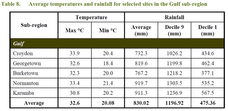
(source: Queensland Primary Industries & Fisheries’ north region An analysis from the top May 2009)
Cape York
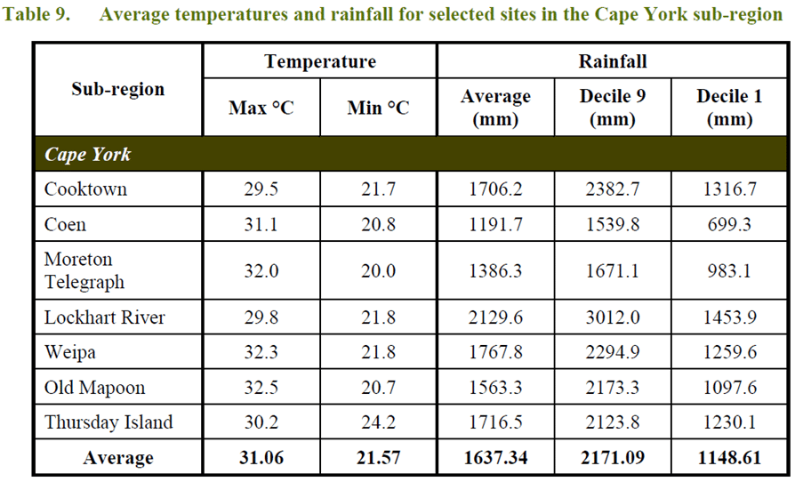
The Cape York sub-region has two distinct seasons, a reliable wet season when rainfall is received, followed by a longer dry season.
Much of the region is dominated by gently undulating plains and plateaus with relatively deep sandy earth but low nutrient status soils. The dominant vegetation is ‘savannah woodlands’ – typically Darwin stringy bark (Eucalyptus tetrodonta) and related eucalyptus species with tall grass understorey. Lower lying areas often
support paperbark (Melaleuca viridiflora) woodlands. Closer to the coast there are estuarine and alluvial plains supporting a range of mangroves, wetlands, vine forests, fringing woodlands, grasslands and a diverse array of other coastal formations. Mainly sandstone, but also older volcanic geologies, form ranges and low hills supporting Eucalyptus spp and Corymbia spp woodlands and scattered mixed species of vine forests.
The major occurrence of terrestrial wetlands is on the massive and littoral shores of the Gulf of Carpentaria, Endeavour Strait, Newcastle Bay and Princess Charlotte Bay. Perched swamps and springs occur on elevated sandstones of the Laura Basin. A total area of 24448660 hectares, consisting of 23 sites, has been assessed as important terrestrial wetlands for Queensland, of which 10 sites (1296470 hectares) are of national significance. Pastoral leases, conservation reserves and Deed of Grant in Trust (Aboriginal land) cover most of the region.
The region is considered to be in a relatively natural state, with the dominant land use being cattle grazing on natural pastures, tourism, nature conservation, traditional land use and mining. There is a current and growing interest in establishing economically viable developments to support the indigenous communities and residents in the region. The pastoral leases are gradually not being renewed and land tenure resolution processes are seeing an increase in both indigenous ownership and conservation reserves.
The Cape and Torres Strait are important buffer zones and quarantine surveillance areas relating to risks of exotic disease from Papua New Guinea. There is a cattle exclusion zone about 50km from the tip of Cape York and sentinel animals are in place to monitor for diseases such as Japanese encephalitis.
(source: Queensland Primary Industries & Fisheries’ north region An analysis from the top May 2009)
Southern Gulf region Climate
The Southern Gulf region lies in north-west Queensland, extending from Karumba to just west of the Northern Territory border. It encompasses all river catchments draining into the southern Gulf of Carpentaria. The landscape includes coastal plains, eastern uplands, Mitchell Grass Downs, and Northwest Highlands. The north is dominated by low-lying plains, primarily within the Gulf Plains bioregion. Rivers flow across these plains, forming branching channels near the coast. Inland, grasslands and eucalypt-Melaleuca woodlands prevail. Floodplains host seasonal and permanent wetlands. Coastal zones feature mudflats, saltmarshes, and mangroves. Uplands in the east support dry rainforests, eucalypt woodlands, and Acacia woodlands.
The south-east of the Southern Gulf region features the Mitchell Grass Downs’ rolling plains, also extending along its southwestern border. The Northwest Highlands, including the Mount Isa Inlier and Gulf Fall and Uplands bioregions, are rugged and dramatic, containing features like the Selwyn Ranges and Lawn Hill Gorge. Snappy Gum and spinifex dominate vegetation, with permanent water found in steep gorges. Most vegetation remains intact, with under 5% cleared. Clearance, mainly for pasture, increased after 2012.
Southern Gulf climate
The climate of the Southern Gulf region ranges from semi-arid environment in the south to semi-humid in the north with most rain falls between November and March.
The region experiences a hot and humid climate, with Mount Isa’s summer maximum temperatures nearing 40°C and winter minimums above 10°C. Summer highs often exceed 40°C. The southern areas have the most extreme temperatures, ranging from 9–27°C in winter and 24–39.5°C in summer, while coastal regions are milder, with 13–28°C in winter and 25–35°C in summer. Humidity during the wet season is up to 10% higher at Burketown than at Julia Creek. Rainfall is highly variable—about one-third of years receive 100 mm more or less than the average. Most rainfall comes from thunderstorms, monsoons, or tropical cyclones.
The Southern Oscillation Index has a high influence on rainfall, and droughts are often associated with El Niño years, and extended periods of high rainfall with La Niña years.
ADD IMAGES
